Insights · 8 min read · Published October 2026
Optical and SAR together: change detection by day, by night and in any weather
An optical sensor sees what a person understands; a radar sees when nothing else can. The value appears when both work as one system.
Key points
- 01Monitoring built on optical alone stops at night and under cloud.
- 02SAR provides continuity; optical imagery and GeoAI provide interpretation.
- 03SAR and optical data can support operational services built around monitoring, change detection and qualified alerts, rather than image delivery alone.
The blind spot of optical monitoring
For a long time, Earth observation was treated as a matter of images: order a scene, analyse it, compare it with the previous one. That model works as long as the sky cooperates. A significant share of the time, it does not. Night, cloud cover, dust or a sandstorm are enough to blind an optical sensor.
In the Gulf and across Africa, these conditions are not exceptions. They are seasonal realities. A monitoring system that switches off precisely when visibility drops leaves a gap exactly where attention should be highest.
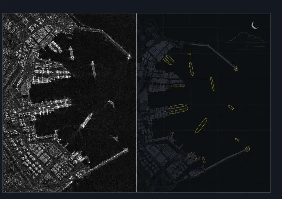
The same port at night, under cloud: the SAR image, then automatically detected vessels. Illustration.
What radar changes
Synthetic aperture radar emits its own energy. It needs neither sunlight nor a clear sky. It measures how a surface returns the signal: a metal vessel, a new structure, disturbed ground or a flooded area stand out clearly, by day or by night.
Commercial SAR constellations have made this capability far more accessible and frequent. Radar is no longer reserved for a handful of national programmes. It is becoming a layer of continuity that mid-sized institutions can realistically consider.
Its limit lies elsewhere: a radar image is less intuitive to read than a photograph. Without method and suitable tools, a decision maker can hold the data without being able to use it.
“SAR provides continuity; optical imagery and GeoAI provide interpretation.”
The detect and confirm loop
Convergence does not mean placing two catalogues side by side. It means organising a loop. SAR observes wide areas continuously and flags a variation. A GeoAI model qualifies that variation and filters out noise. The alert then triggers a targeted optical acquisition at the next clear window, or verification by other means.
Each sensor then does what it does best. Radar ensures that no period escapes observation. Optical imagery provides the visual context an analyst or a manager recognises immediately. AI shortens the time between signal and decision.
Conditions on the ground
In the field, the question is never purely technical. Who receives the alert, in what form, within what timeframe and with what accountability? A relevant detection that lands in an inbox nobody owns has no operational value.
False positives matter as much as missed detections. A team alerted too often stops trusting the system. The quality of a capability is therefore judged by its ability to produce alerts that teams are willing to act on.
Conditions on the ground
What this changes for evaluation
This shift changes the question organisations ask. Many users care less about scene counts or nominal resolution than about a simple question: will I know in time about a change that matters, whatever the hour or the weather?
When organisations evaluate an operational monitoring service, useful criteria can include the monitored area, observation frequency, delivery time and the level of confirmation required. This shifts the discussion from access to imagery towards the operational value produced from the data.
For decision makers
A useful way to frame the requirement is to start with the decision to be supported rather than with the sensor alone. Which changes must be known, over which areas, how quickly, and what happens next? Once those answers exist, the combination of optical, SAR and GeoAI almost sizes itself.
Optical alone gives a clear but intermittent view. SAR alone gives continuity but requires interpretation. Together, organised around a stream of qualified alerts, they deliver what operations actually expect: situational awareness that does not stop at sunset.
This article explains publicly documented remote-sensing principles and reflects the author’s personal analysis. It does not describe any confidential customer, programme, procurement or employer information.